Community Development
Community Development “On-Reserve”
The following outlines our framework for community development on our reserve lands. Detailed plans have been developed for IR#18, IR#13 and IR#1 and can be found in Appendix A, B and C respectively.
| Traditional Place Name | Current Reserve Name | Historic Use | Goal(s) for the Future |
| x̱wa̱tis | IR #1 – Quattishe | Village and resource site (gardens, fishing, hunting… etc.). This was our principal village until the 1970’s. There are several burial sites located here. | See Appendix A |
| t̓u̓goyu̓ | IR #2 – Toh-quo-eugh | Fishing station with several buildings | To build cabins and campsites for members |
| pa̱kyatła̱m | IR #3 – Pa-cat’l-lin-ne | Fishing station with several buildings | No development (continue to fish here) |
| k ̓a̱lta̱la ̓akw | IR #4 – Kultah | Village and resource site (gardens, cod fish… etc.) | To build cabins and campsites for members |
| x̱a̱ ̓eł | IR #5 – Cayilth | Fishing station with several buildings | To build cabins and campsites for members |
| k ̓a̱ ̓es | IR #6 – Cayuse | Fishing and clam harvesting station with several buildings | To build cabins and campsites for members and restore beach for harvesting shellfish |
| titax̱ | IR #7 – Teeta | Fishing station with several buildings | To build cabins and campsites for members |
| ma̱ladi | IR #8 – Mah-te-nicht | Village and resource site (gardens, dogfish, salmon… etc.). The sockeye fishery was particularly important with a network of weirs. | To build cabins and campsites for members
Rehabilitate sockeye and re-establish fishery with weirs |
| dłada̱k ̓wa̱s | IR #9 – Clatux | Village and resource site (gardens, clams, abalone, salmon… etc.) | To build cabins and campsites for members and infrastructure to support sustainable clam fishery (aquaculture) |
| oyag̱a̱m ̓la | IR #11 – O-ya-kum-la | Village and resource site (gardens, halibut, dogfish, dentalium… etc.) | To build cabins and campsites for members
Other infrastructure to support cultural “rediscovery” camps |
| g̱watłiyu ̓ | IR #12 – Quatleyo | Seasonal campsite with cabins and an access to resources (fishing, hunting… etc.) | To build cabins and campsites for members |
| siba ̓a | IR #13 – Grass Point | Village and resource site (fishing, hunting… etc.). Some of our members still have cabins here. A large portion of this site was taken and given to European settlers. | See Appendix B |
| tłi ̓yana or da̱ ̓nade ̓ | IR #14 – Clienna | Village and resource site (gardens, seasonal fishing, clams… etc.), past logging camp | To build cabins and campsites for members |
| ? | IR #15 – Pulcah | Burial ground | No development |
| gugo ̓ya̱we | IR #16 – Ah-we-cha-ol-to | Village and resource site (fishing, hunting… etc.) | To build cabins and campsites for members |
| ma̱kwex̱to ̓wi | ̓ IR #17 – Maquazneecht Island | Burial ground | No development |
| ? | IR #1 – Telaise | Village and resource site (salmon fishing, berry picking, hunting… etc.) | To build cabins and campsites for members |
| t ̓sa̱ ̓wa̱nx̱as | IR # 2 – Tsowenachs | Village and resource site (fishing, trapping… etc.) | To build cabins and campsites for members |
| tła̱sg̱as | IR # 3 – Klaskish | Village and resource site (gardens, halibut, trapping… etc.) | To build cabins and campsites for members |
| n/a | IR # 18 – Quatsino Subdivision | Our members were relocated here in the 1970’s. | See Appendix C |
Community Development “Off-Reserve”
Reserves were not established for all of our historic village and resource sites. Map 1 (page 12) identifies some of our key sites located “off-reserve”.
Important Note -> The traditional Quatsino settlements and sites shown on Map 1 may not represent the entirety of those known or used by our people.
These sites remain important to our people even though they are not located “on-reserve”. Developing infrastructure that will make it easier for our members to practice our traditions and harvest resources at these key “off-reserve” sites is priority. This includes – but is not limited to:
Building campsites and cabins;
Developing trails
Installing interpretive signage that tells our stories and highlights our connection to sites
Installing docks
Building smoke houses.
Private Land and Leases…
In addition to reserve-lands, Quatsino First Nation holds private (fee simple) land and tenures within the Territory. They present opportunities for the Nation to pursue economic development opportunities.
Action Item -> Specific opportunities for these lands will be identified and assessed as part of our Economic Development Plan. The Economic Development Plan will provide the specific direction and guide future development.
Future Land Acquisitions
We are running out of developable land at our main community (IR#18). Land acquisitions are now required to accommodate continued population growth and investments in community development.
Community Land Needs
This section of our land use plan outlines our basic community land needs.
Residential Land Needs
Quatsino First Nation’s population currently consists of 566 registered members. 42.5 percent of this population lives “on-reserve” in our main community (IR #18). 3.2% of the population lives “on-reserve”, but in other First Nation communities. The remaining 52% of the population lives “off-reserve”. Overall, our population is steadily increasing. The number of registered members has grown from 334 to 566 – a 69% increase – since 1997. However, as Figure 1 (next page) indicates, most of this growth has occurred “off-reserve”. Our “on-reserve” population has only grown by 25% since 1997.
The following issues have been identified as key reasons for our relatively low “on-reserve” growth rate:
Housing Supply
There appears to be an inadequate supply of housing in the community for members who would prefer to live “on-reserve”. This demand is particularly important for our younger members who are looking to secure a home to start a family. Currently there are 4 infill lots and 4 empty homes available, however, these homes do not meet the needs of members on the housing wait-list.
Housing Quality and Conditions
Poor housing quality and conditions appears to be forcing some members to seek more suitable and healthy living conditions “off-reserve”.
Amenities
More amenities such as recreational facilities, health care, and shopping opportunities are available “off-reserve”. These amenities appear to be drawing some people away from our main community.
Employment and Education Opportunities
We do have a school located “on-reserve”; however, many young people are still leaving our main community seeking meaningful employment opportunities elsewhere. This also applies to people seeking post secondary education, enhanced skills training and upgrading.
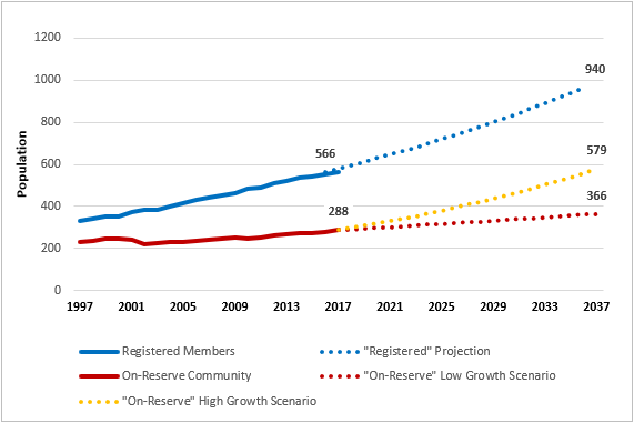
Figure 1: Quatsino First Nation: Historic Growth and Projections [7]
Important Note -> We have assumed that 20% of our overall “on-reserve” population are “non-members” that are living in the main QFN community at IR #18. This assumption is factored into our population projections.
Figure 1 (above) also includes several growth projections for the future:
Projection for ALL Registered Members
This 20-year projection (i.e., the blue dotted line) sees the number of registered members grow from 566 to 940. This is consistent with our historic growth rates (i.e. a 2.7% average annual growth rate for the last 20 years).
“On-Reserve” Projection (Baseline Scenario)
This scenario (i.e., the red dotted line) is specific to our “on-reserve” community. It is a continuation of the status quo and reflects a 1.2% average annual growth rate to the year 2037.
“On-Reserve” Projection (Improved Scenario) <- Used for Community Planning
This scenario (i.e., the orange dotted line) is also specific to our “on-reserve” community. However, this scenario assumes we are able to successfully address the issues identified on the previous page. It is assumed that this would result in members “moving back” pursuant to our transfer policy, with approximately 60% of all registered members living in our main community (IR #18) by the year 2037. With this scenario we would need to accommodate an additional 291 people “on-reserve” by 2037.
[7] Source: Indigenous & Northern Affairs Canada
The following assumptions have been made in determining the amount of residential land that will be required to accommodate an additional 218 people:
- Existing housing will remain in its current form.
- Future housing will consist of 85% single family units and 15% multi-family units.
- Future single family lots will (on average) be 1/3 of an acre. This is the maximum density that is currently eligible for full funding through Indigenous Services Canada.
- Future multi-family lots will be based on a 20 unit per acre population density. This is based on an example of moderate density housing located at Tsleil-Waututh Nation.
- In the future, there will be (on average) 2.5 people per dwelling. This is a standard occupancy rate found in most healthy communities.
- An additional 20% of the land required for single and multi-family housing will be allocated for roads and related above-ground servicing for the residential units.
Based on the assumptions listed above, approximately 30.4 acres of residential land will be required to accommodate an additional 218 people living on KFN community lands in the future. The table below provides a summary of the residential land needs calculation used.
| Current Supply
amount of land available to accommodate future residential growth |
|
| Additional people living on “On-Reserve” by 2037 | 291 |
|
99 (85% of units) |
|
17 (15% of units) |
| Total number of units required | 116 |
|
33.0 ac |
|
6.6 ac |
|
0.9 ac |
|
0.2 ac |
| Total residential land required | 40.6 ac |
As outlined in the table below, we need to acquire approximately 28.2 acres of land to accommodate anticipated population growth over the next 20 years.
|
Current Supply amount of land available to accommodate future residential growth |
20 Year Demand amount of land that will be required to accommodate future residential growth |
Shortfall amount of land that must be acquired to accommodate future residential growth |
|
Assumptions: Development will be feasible on all land identified in this plan for future residential use (see Appendix A).
|
Assumptions: Ones listed above. 12 existing homes must be relocated – further increasing demand. (see Appendix A) |
|
| 12.4 acres | 40.6 acres | 28.2 acres |
Other Community Land Needs
Our community land needs not limited to residential needs. We also need to acquire land for the following purposes:
Community Uses
This includes community buildings and institutions. Examples include recreation facilities, cemeteries and cultural spaces (e.g. space for a Big House).
Parks and Greenspace
Parks and greenspace are important for a healthy and vibrant community. As our community grows we will need to acquire land for parks and greenspace. The “Planner’s Estimating Guide” is published by the American Planning Association (APA). This document contains “recommended provision standards” for parklands and greenspace that are widely accepted throughout North America.
Economic Development
This includes lands suitable for commercial and industrial development. Creating employment opportunities for members “on-reserve” and generating new sources of revenue will be key to retaining members in our community and achieving financial independence. Unfortunately, our ability to pursue economic development initiatives is limited due to a shortage of suitable land. It is anticipated that future land acquisitions and land requirements will be guided by our community Economic Development Plan once it is complete.
Water
Currently, Quatsino First Nation’s water is sourced from Kwakiutl’s Territory. Without direct control over the source, Quatsino First Nation is subject to outside control over the water supply. Ensuring safe, clean, and plentiful water is an important consideration of future land requirements.
Agriculture and Food Security
Food security is a priority for our people. Our historic villages were noted for their large community gardens. Unfortunately, our current community does not have land suitable for cultivation. Additional land is required to address this issue.
Waste Management
Opportunity to address waste management on-reserve is limited and requires capacity improvements as the community grows. Adequate lands for the necessary waste management infrastructure will be needed.
Land Selection Strategy
Three basic principles have been established to guide future land selection processes:
Reconnect with the ocean
This is the most important principle (see figure below). We are a people with a strong connection to the ocean. That connection has been damaged due to our relocation inland in the 1970’s. Acquiring developable oceanfront land in Coal Harbour will be the starting point for all future land acquisition discussions.
Accommodate all community land use needs on reserve
This means having land that can accommodate all community land needs outlined in Section 5.3.1 of this Land Use Plan.
Establish logical connections
Our goal is to bring our people back to the water while remaining connected with our current community. This means acquiring land on the water for new community and cultural infrastructure (e.g. Big Houses) and suitable land next to IR#18 for new housing. These nodes should be connected by logical and contiguous boundaries whenever possible.
Member feedback from Community Meeting in 2018